Площадей псто...
Sep. 9th, 2015 10:24 amОригинал взят у ![[livejournal.com profile]](https://www.dreamwidth.org/img/external/lj-userinfo.gif) lazy_flyer в Площадей псто...
lazy_flyer в Площадей псто...
Наверное все, имеющие контакты с беспилотной авиацией не раз слышали, как дёшево беспилотник получается. В смысле построить, обслужить, а потом на горА выдавать результат. В смысле фотачки и видосики.

Но нормальный инженер обязан быть скептичен. И нормальный инженер конечно верит россказням продавцов и маркетологов. Но потом берёт калькулятор и начинает считать...
Получается иногда забавно, о чём пишет группа исследователей.
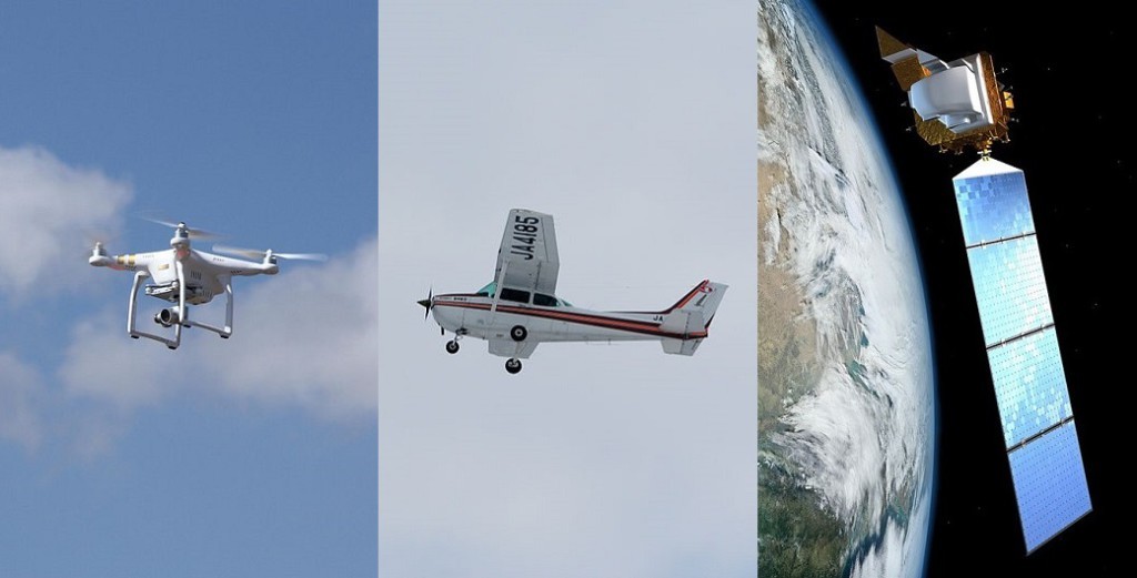
Intercomparison of UAV, Aircraft and Satellite Remote Sensing Platforms for Precision Viticulture.
Оказывается, мелкие БЛА оправданы к использованию на малых площадях.

Да, дёшево. Да, фотачки. Но только если огород отснять. Но если у вас больше 50 гектаров - поищите спутниковые снимки.
The understanding of the intra-vineyard variability is a keystone to implement effective PV practices, especially in Mediterranean environment where the land-use patterns are highly fragmented and vineyards present high heterogeneity because of soil, morphology and microclimate variability. Our study, based on the comparison of different remote sensing platforms, highlighted that different resolutions provide similar results in the case of vineyards characterized by pronounced vegetation gradients and large vegetation clusters. On the contrary, in vineyards characterized by small vegetation gradients and high vegetation patchiness, low resolution images fail in representing intra-vineyard variability and its patterns. Furthermore, considering the peculiarity of vineyards crop structure, our work points out the impossibility of distinguishing canopy and inter-rows in the case of low-resolution images, something that limits the applicability of this platforms in the case of variable rate spraying.
The cost analysis shows that, beyond technical aspects, an economic break-even between UAV and the other platforms exists between 5 and 50 ha of area coverage, and also that aircraft remote sensing remains competitive with satellite above such threshold.
Конечно никто не запрещает утюжить мелколётом с высоты 100 метров 100 гектаров площадей. Но следует понимать, что ни дёшево ни быстро это не будет.
Но нормальный инженер обязан быть скептичен. И нормальный инженер конечно верит россказням продавцов и маркетологов. Но потом берёт калькулятор и начинает считать...
Получается иногда забавно, о чём пишет группа исследователей.
Intercomparison of UAV, Aircraft and Satellite Remote Sensing Platforms for Precision Viticulture.
Оказывается, мелкие БЛА оправданы к использованию на малых площадях.

Да, дёшево. Да, фотачки. Но только если огород отснять. Но если у вас больше 50 гектаров - поищите спутниковые снимки.
The understanding of the intra-vineyard variability is a keystone to implement effective PV practices, especially in Mediterranean environment where the land-use patterns are highly fragmented and vineyards present high heterogeneity because of soil, morphology and microclimate variability. Our study, based on the comparison of different remote sensing platforms, highlighted that different resolutions provide similar results in the case of vineyards characterized by pronounced vegetation gradients and large vegetation clusters. On the contrary, in vineyards characterized by small vegetation gradients and high vegetation patchiness, low resolution images fail in representing intra-vineyard variability and its patterns. Furthermore, considering the peculiarity of vineyards crop structure, our work points out the impossibility of distinguishing canopy and inter-rows in the case of low-resolution images, something that limits the applicability of this platforms in the case of variable rate spraying.
The cost analysis shows that, beyond technical aspects, an economic break-even between UAV and the other platforms exists between 5 and 50 ha of area coverage, and also that aircraft remote sensing remains competitive with satellite above such threshold.
Конечно никто не запрещает утюжить мелколётом с высоты 100 метров 100 гектаров площадей. Но следует понимать, что ни дёшево ни быстро это не будет.
no subject
Date: 2015-09-09 08:10 am (UTC)no subject
Date: 2015-09-09 08:24 am (UTC)